
Visual Tour San Pedro de Atacama Chile 7 Best Places to See
Why Go on a Visual Tour of San Pedro de Atacama?
Enormous salt flats with flocks of bright pink Flamingos. Out-of-this-world Rock Formations. Giant Dunes. Multi-colored rocks of Rainbow Valley. Views of the Andes. Early morning geysers. Millions of stars in the night time sky. A visual tour of San Pedro de Atacama is stunning.
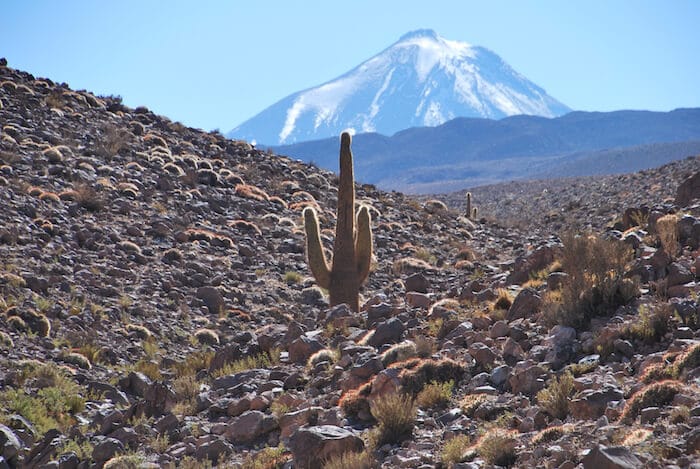
Located in the north of Chile, San Pedro De Atacama lies between the Andes and a coastal Mountain range.The Atacama Desert in Chile is one of the driest places on earth with an average annual rainfall of 15 mm a year. It spans 600 miles (1,000 km) long or 41,000 square miles. Like all deserts, temperatures vary widely from day to night–from 40º C (104º F) to 5º C (41º F) at night.
Our Chile Itinerary took us from Santiago to Valparaiso to Easter Island to San Pedro de Atacama. We expected to be amazed by Easter Island the the Moai. And, we were.
We did not know that the Atacama Desert would be equally stunning.
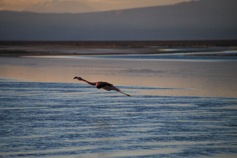
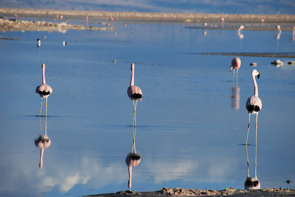
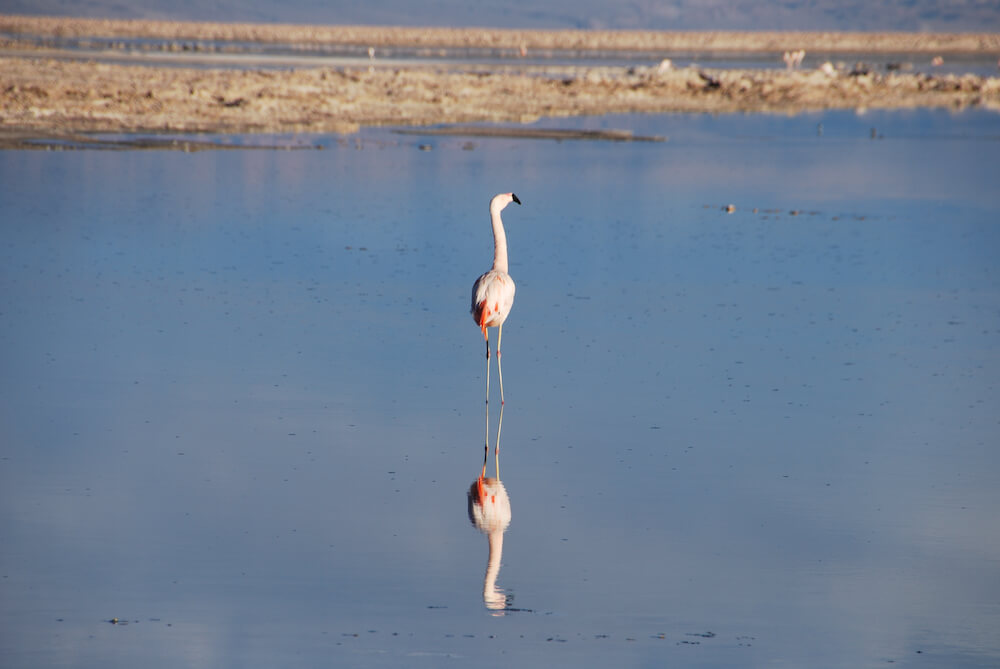
Flamingos in Flight at the Atacama Salt Flats (Salar de Atacama)
An hour’s drive (34 miles or 55 km) from San Pedro de Atacama, we arrived at Salar de Atacama–an enormous salt flat (1,200 square miles or 3,000 sq. km), full of flamingos. The first stop on our visual tour of San Pedro de Atacama. Our plan was to arrive just before sunset so we could film the flamingos as they took flight. They put on a show for us. It was beautiful to watch.
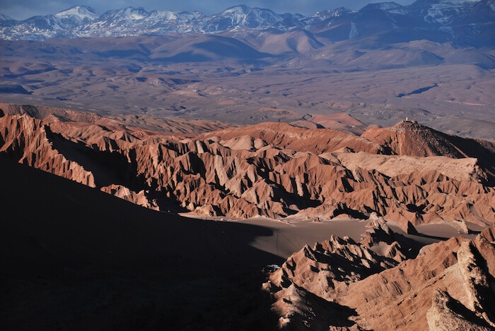
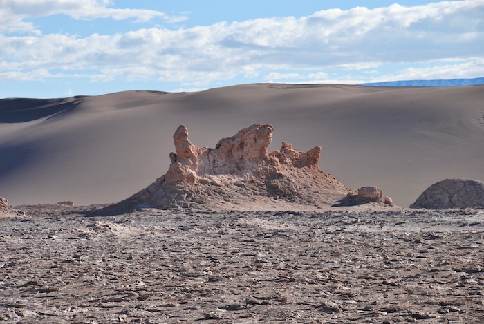
Unusual Rock Formations at Moon Valley (Valle de La Luna)
Next stop on our visual tour of San Pedro de Atacama was Moon Valley. A short drive outside of San Pedro de Atacama, we arrived at the Moon Valley or Valle de la Luna. Approximately 7,500 feet (2,500 km) above sea level, it really was like being on another planet. It is part of the Cordillera de la Sal or the Salt Mountain Range–a mountain range with a very high salt content. The rock formations and terrain were shaped by the wind and sand.
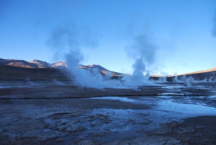
Experience the El Tatio Geysers
We woke up at 4 am, excited to see El Tatio Geysers at sunrise. We proceeded to put every single piece of clothing that we brought with us. The Geysers are the highest in the world at 14,000+ feet above sea level, making a dawn trip very cold. We had neglected to consider that in our packing, so did not have enough warm clothing. Hence, the need to wear every single piece of clothing that we brought.
We set out with a guide for the 1.5 hour, very bumpy drive up the mountains. The Geysers are most powerful early in the morning and so we decided to photograph the geothermal field at that time. The fields are spread out and it was very interesting to walk through them.
For more of our cold weather adventures, check out out trip chasing the Northern Lights: Tromso Northern Lights Tour in Winter–Was it Worth the Wait?
And, if you want to know what we should have brought to see the Geysers, read: Best Antartica and Winter Travel Packing List
See the Night Sky
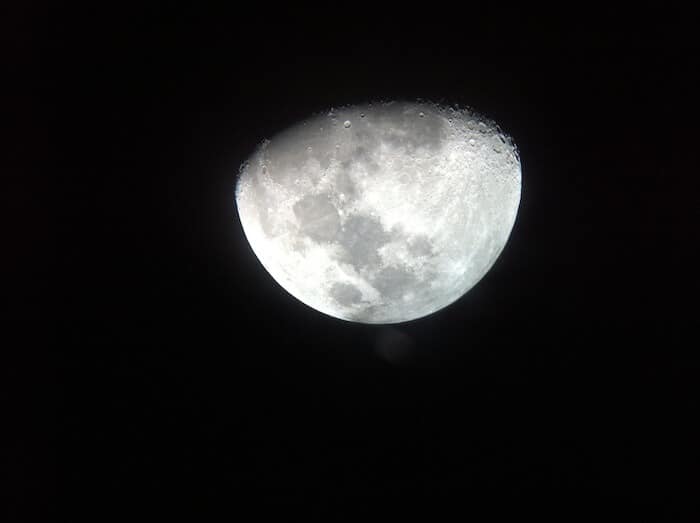
The desert is a great place to see the night sky. No visual tour of San Pedro de Atacama is complete without a trip to an observatory. The tour started at 10 pm and went arrived back at our hotel around 1 am. In between was magic. We listened to a lecture on the constellations of the Southern hemisphere-helpful for those of us from the North. Then we had a chance to peer through our own telescope at the moon and other planets. The picture above was taken through the telescope on an iPhone–our one regret was that we did not bring our DLSR.
Go Back 10,000 Years to See the Yerbas Buenas Petroglyphs
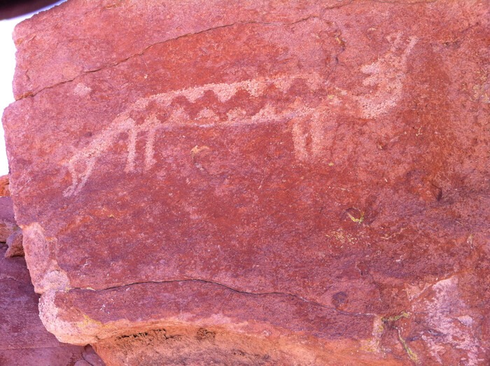
About 10,000 years ago, the Atacameno people lived in a fertile area. This was long before Atacama became a desert. The Yerbas Buenas Petroglyphs date from this era. There are many petroglyphs and we could have spent the entire day wandering around. We particularly liked this two-headed animal petroglyph.
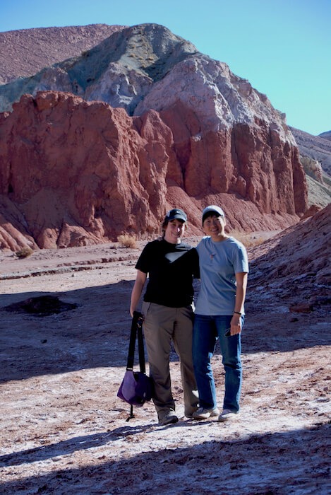
A Mountain of Rainbows at Rainbow Valley
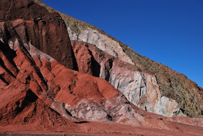
If you have visited the Painted Desert in the United States, Rainbow Mountains need to be part of your Visual Tour San Pedro de Atacama. The colors are vibrant and the mountains area shaped by wind into interesting shapes. We were there by ourselves and enjoyed a walk through the mountains.
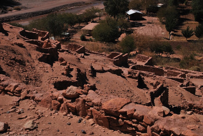
Climb Pukara de Quitor
Pukara de Quitor was built by the Atacamenos in the 12th century as a defense against the Incas, and later, the Spaniards. It is a short 3 km walk from the center of San Pedro de Atacama. This fort had houses, shelters for animals, warehouses and other structures. Some people rent bikes to get there. The view from the fort is breathtaking, though that might have been from the climbing!
Have you been on a Visual Tour of San Pedro de Atacama? Leave a Comment.
Please Pin and Share


What an amazing place. I would love to explore the salt flats and the rainbow mountains. Such a beautiful and ancient culture.
It is so beautiful in San Pedro de Atacama. Really worth the trip
You won me over at the flamingos.
The landscape in Chile is stunning—I don’t think I realised how dramatic and beautiful it is until we fly into Santiago on our way to Colombia recently. I love petroglyphs so that would be a highlight for me! Can’t wait to visit this beautiful country properly one day soon!
Wow! it’s incredible how much history and nature can be packed into one area! Looks like you had an unforgettable trip!
It was an unforgettable trip indeed.
I’ve had my eye on San Pedro de Atacama for a while now. It looks like such an other-worldly landscape. Especially under that epic night sky! But I didn’t realize there was such a rich cultural aspect to the area as well. Very interesting read.
The Atacama is on my bucket list! I love those spare landscapes.
There is so much to see there. Make sure to leave enough time. We could have used another couple of days.
Great post and let me tell you, I just love your pictures, I think I need to go back to Chile!
Thanks! I need to go back to Chile too. It’s a great place to visit.
These photos are stunning. I love the ancient petroglyph and that shot you were able to get with your iPhone and a telescope. Super creative!
Thanks Katie. It was amazing to get that photo through a telescope. And, there are many petroglyphs to see.
Wow. Looks fabulous. I’m a bit jealous of your flamingo photos. I see flamingos all the time where I live but never close enough to get such stunning pictures.
Except for the Salt Lake with the Flamingos, you could tell that all these pictures were taking in the moon and I would believe you. Amazing landscapes and I would love to see the petroglyphs! Thank you for sharing
Thanks for your comments. There are a lot of petroglyphs to see.
Thx for this glimpse of the Atacama Desert and San Pedro. I’ve not yet been to Chile, but it looks like this part of the country is tops for the adventurous.
I hadn’t read anything about this area before. It looks beautiful and so peaceful. Love the flamingos.
Judy-Thanks. It is a wonderful area to visit.
What gorgeous photos. I don’t think I’ve ever seen a flamingo in flight before. Simply stunning!
Thank you Sue. It was fun to see the Flamingos in flight.